
It has been a long time in coming, but here is the ‘rest of the story’ about our ride from Estes Park to Utah and western Colorado, back in August of 2018.
We left Dinosaur National Monument on a mission to see another incredible National treasure just over 100 miles south near Grand Junction, Colorado, the Colorado National Monument.
The most direct route, which we did not really research, was east on US 40, a quick hop on CO 64, to dead south on CO 139. I mentioned that we were on a mission…it was just after noon when we left Dinosaur, and we weren’t hungry, so we decided to ride directly south. We wanted to make the most of the late summer day once we reached the monument. We had no idea how amazing the ride would be, or that CO 139 traversed a very remote, unpopulated region with many twists, turns, and incredible scenery. Nor that it is featured on dangerousroads.org. 😉 About midpoint, the road crosses the Bookcliff Mountains at Douglas Pass, with an elevation of 8,268 ft (2,520 m). Since we were on a mission, we didn’t even stop for photos. Fortunately for us, Douglas Pass is well documented online.

Douglas Pass photo courtesy of dangerousroads.org
After the pass, the road dives down through a couple of switchbacks into an area known as Canyon Pintado. Unfortunately, our lack of research caused us to miss a National Historic District featuring hundreds of archaeological sites including Native American rock art over 16,000 acres of public land, most deriving from the Fremont Culture (c. AD 0_1300) and Ute (c. AD 1300_1881) occupations of the Douglas Creek canyon. Driving through doesn’t count, so we’ll just have to go back!
We stopped briefly in Fruita, just off I-70 north of Grand Junction, for a quick bite to eat at a first for us, an Ace Hardware on steroids called Co-op Country. It had everything from hardware to cowboy couture to great food and drink! It was amazing and we enjoyed our sandwiches with a view of the widely varied goods and customers!
Once we had fueled both ourselves and our steeds, we rode just south of I-70 to the west entrance of Colorado National Monument. It was literally a stone’s throw from the bustling city of Grand Junction, and just off the Interstate.

Colorado National Monument, or COLM, established in 1911, was the dream of a solitary soul who lived in the desolate canyon country, John Otto. He arrived in the area in 1906 and made it his mission to promote the spectacular landscape as a national park. He urged the residents of the area to deluge D.C. politicians with letters and petitions supporting his proposal, meanwhile building miles of trails in the proposed park area so that others could see and appreciate its beauty. In 1911, his dream came true and the National Monument was established. Otto was named the park’s caretaker, a job he enthusiastically held until 1927 for just $1 per month.

The Uncompahgre Plateau makes up the high country portion of the monument, and it rises over 2,000 feet above the Grand Valley of the Colorado River. It was created millions of years ago during the upheaval that created the Rocky Mountains and is part of the greater Colorado Plateau, which includes other magnificent geologic features such as Grand Canyon, Bryce Canyon, Arches, and Canyonlands national parks.
COLM consists of the plateau, with its incredible views of the river valley, colorful canyons, and fascinating rock formations to deep backcountry canyons carved by millions of years of erosion and graced with incredible rock sculptures that tower over the canyon floor. All through these natural wonders, 23-mile-long Rim Rock Drive is your ticket to all the monument has to offer. It is a magic carpet ride you will never forget!


Our next stop was the Visitors Center, approximately 4 miles from the west entrance. We browsed the exhibits and marveled at the model of the monument, before heading outside for the views on the Canyon Rim Trail.


Our next stop was at Independence Monument Overlook, surveying the towering and majestic monument and Wedding Canyon, which has a sad backstory, despite its incredible scenery.
From the NPS website:
“John Otto married Boston artist Beatrice Farnham on June 20, 1911 at the base of Independence Monument. Unfortunately, John and Beatrice’s marriage was short-lived. Beatrice found the reality of John’s life to be far from her romantic ideal. A few weeks after the wedding, she left, never to return.
“I tried hard to live his way, but I could not do it, I could not live with a man to whom even a cabin was an encumbrance.” Beatrice Farnham Otto”


The next stop was the impeccably named Grand View overlook. The expansiveness of the landscape is almost impossible to comprehend, much less photograph. But I tried! A series of photos plus a video almost does it justice.


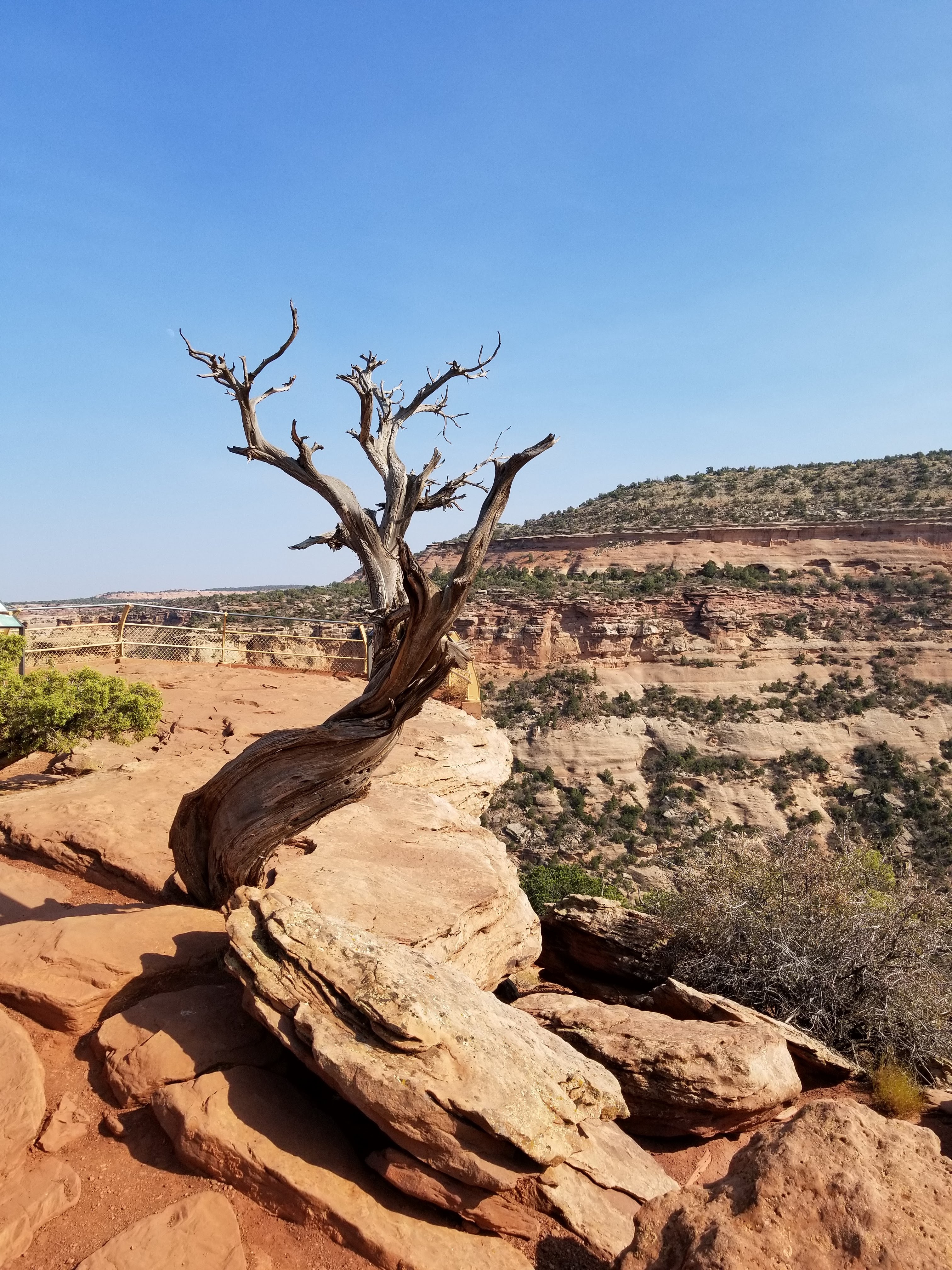
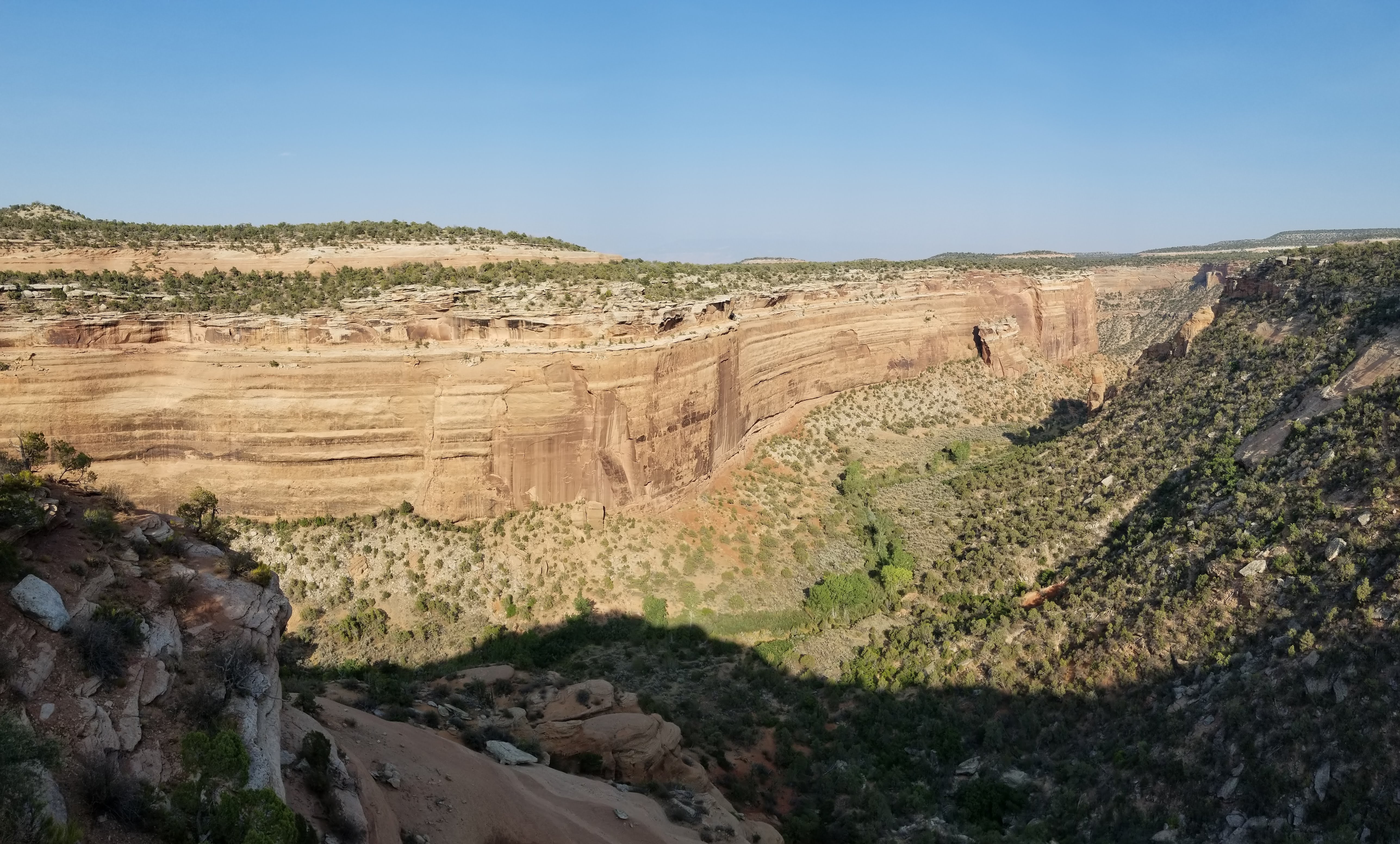
Nature’s sculpture garden
We finally tore ourselves away from Grand View and continued on Rim Rock Drive to the Coke Ovens overlook.
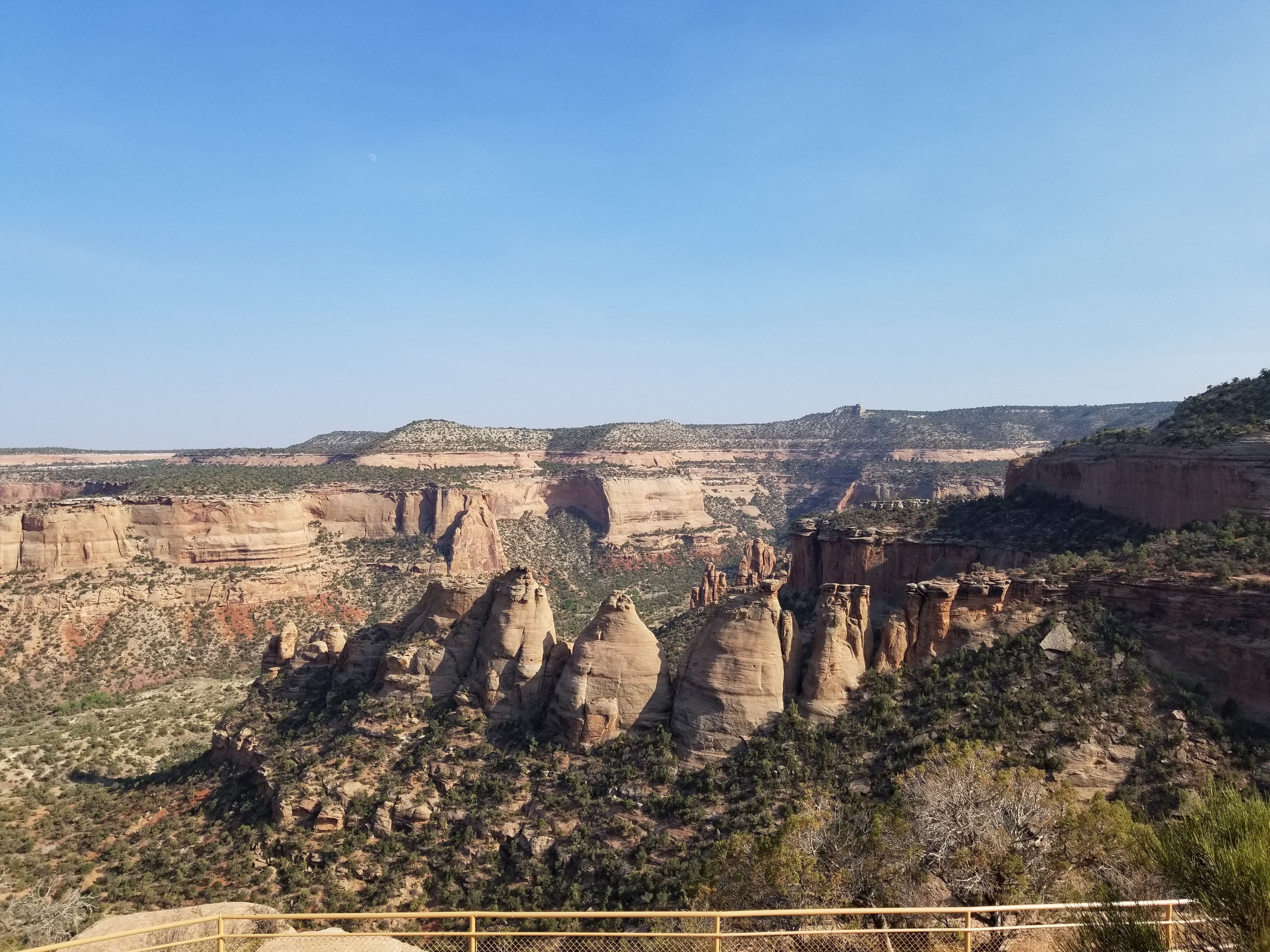
The Coke Ovens are a series of colorful rock domes created by the intense forces of water, wind, and ice. The harder rock layers, such as the Kayenta, which forms the protective caprock of angular rock forms like Independence Monument, are more resistant to erosion. But once eroded, rounded shapes like those of the coke ovens are formed from the softer underlying layers.
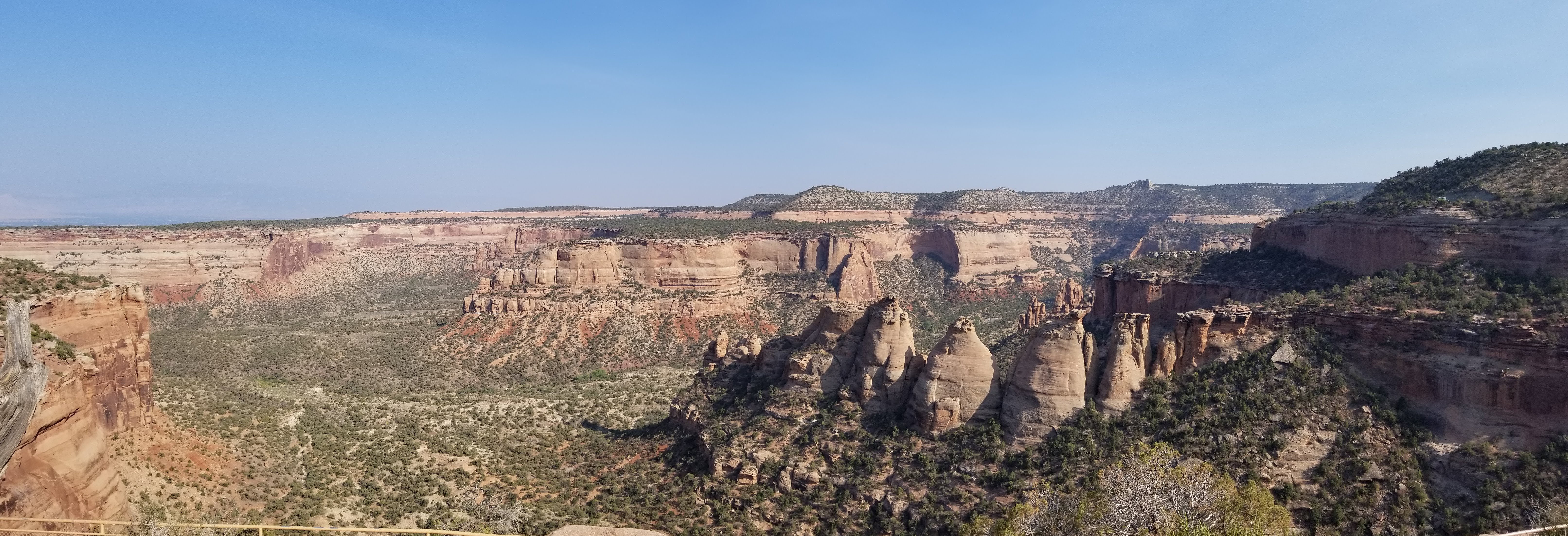
Panorama of Monument Canyon and the coke ovens
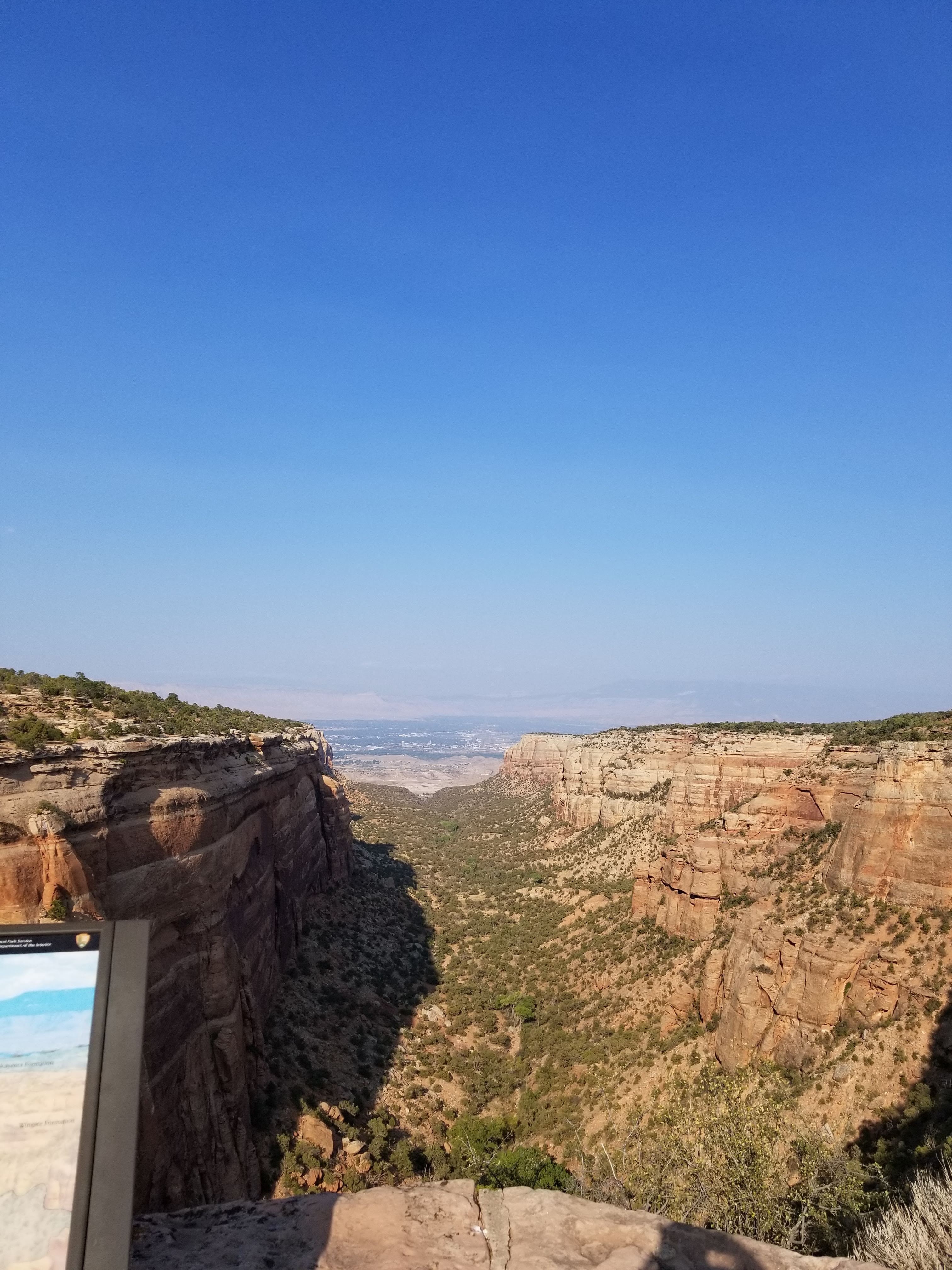
We moved on to an overlook called Artists Point, which is named for the beautiful panorama of canyons, cliffs, and brightly colored
rocks that you see in the foreground and hills adjacent to the overlook.
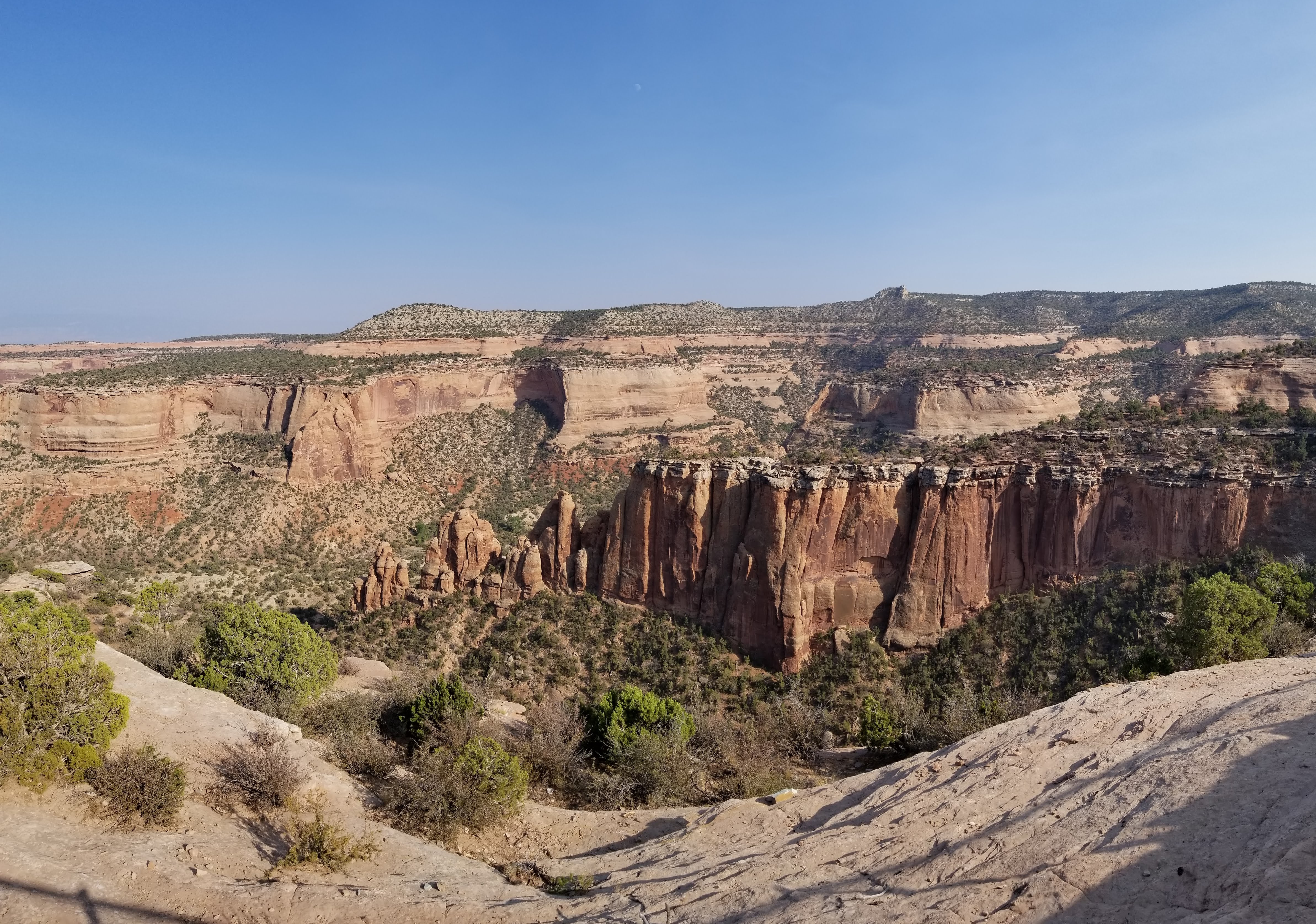
View from Artists Point
The light was beginning to drop closer to the horizon so we hurried to a couple more stops before it got too dark, or too cold, whichever came first. 😉
Shadows approach as we gaze over Ute Canyon
Our last stop in the monument, Red Canyon Overlook.
I hope you have enjoyed this small taste of the incredible Colorado National Monument. We loved this treasure, and definitely, plan to return with more time to hike and really get down into the canyons to fully experience the majesty.
After our visit, we spent a fun evening walking downtown Grand Junction, enjoying dinner and adult beverages before retiring to our hotel to rest up for the 300+ miles back to Estes Park the next day.
We were amazed by the beauty of the ride on I-70; despite its interstate status, the scenery was beyond gorgeous. The towering cliffs, flowing rivers, and expansive views made the 300 miles pass by in a flash.
We also made a note to return to the Grand Valley, the home of Colorado’s wine growing region. It’s a good thing we are returning to Estes Park in May 2019 since we have a lot of Colorado sightseeing left to do!


[…] the third part of this saga, covering Colorado National Monument, in Grand Junction, is available at this link. Please join us again soon, as the adventures […]
LikeLike
I can’t wait until we can explore all the nooks and crannies we missed before.
LikeLiked by 1 person
My sentiments exactly! Take it slow and see ALL the sights! ❤
LikeLike
All of the pictures above the “Grand View” video didn’t show for me? The Red Canyon is spectacular though!
LikeLike
Well that is strange. I just checked and they loaded for me. Hmmm.
Merry Christmas!!! 🎄🎅
LikeLiked by 1 person
Who says desolation isn’t beautiful or filled with life?
Well done and thanks for opening my eyes once more.
LikeLiked by 1 person
Thank you for gracing my post with your presence and wise words!
LikeLike
Hey, I do what I can.
LikeLike
Ahh, Douglas Pass: I’ve ridden it twice, and I completely understand its dangerous road status–unusual slopes, irregular curves, and damaged, uneven pavement… BTW: Put Palisade Brewing Company on your list–it’s a great pub, a favorite of mine.
LikeLiked by 1 person
Yes, Ry, you’re exactly right about Douglas. We will add Palisade to our list for sure! 🍺
LikeLiked by 1 person